Phase II Archaeological Investigation: Site 44WB 90, Williamsburg, VirginiaBlock 33 Building 2
Colonial Williamsburg Foundation Library Research Report Series - 1683
Colonial Williamsburg Foundation Library
Williamsburg, Virginia
2002
Phase II Archaeological Investigation: Site 44WB 90, Williamsburg, Virginia
Principal Investigator
Marley R. Brown III
Colonial Williamsburg Foundation
Department of Archaeological Research
July 1997
Re-issued
April 2001
Management Summary
During November and December of 1996, staff members from the Colonial Williamsburg Foundation's Department of Archaeological Research conducted a Phase II investigation of Site 44WB90 located adjacent to the Colonial Williamsburg Visitor's Center in Williamsburg, Virginia. This evaluation assessed the resources previously identified during a Phase I survey of the area in June 1996 (Pickett 1996). This initial survey was conducted because of impending development of the area.
Upon completion of the Phase I survey, a Phase II investigation was deemed necessary due to a cluster of positive shovel tests that contained eighteenth-century artifacts. This material appeared to be domestic refuse. Thus, the secondary investigation was designed to systematically test the area of concentration in order to substantiate and delineate this possible domestic site.
The Phase II consisted of twenty four 75 cm by 75 cm excavation units, two 1 m by 1 m units, and one 2 m by 2 m unit. This testing confirmed the presence of an eighteenthcentury site. The associated artifacts and features suggested that this site served as a dwelling for an individual or family. Intact architectural remains consisted of an English-bond, brick hearth foundation and an associated robber's trench. The sparse amount of brick encountered during the excavation indicated that the structure was constructed of wood which rested on posts. A thin scatter of eighteenth-century domestic and architectural artifacts were also recovered. There was a high correlation between artifact density and the location of the brick hearth foundation. Artifact distribution maps also suggested the presence of a household refuse midden and non-domestic wooden structure.
Historical research indicated that this house may have been located on a 35 acre tract owned by Matthew Moody and sold in 1760 to Lieutenant Governor Francis Fauquier. The site has a high research potential since it was most likely inhabited by an individual of low, socio-economic status. Historical documents seldom contain information concerning the lives of such individuals. Archaeological investigation of this site will illuminate this little known past. Thus, it is recommended that the site be preserved. If preservation of the site is not possible, then Phase III data recovery should be performed.
| Page | |
| Management Summary | i |
| Table of Contents | iii |
| List of Figures | iv |
| Chapter 1. Background Information | 1 |
| Introduction | 1 |
| Environmental Setting | 1 |
| Historic Context | 3 |
| Site Historical Context | 6 |
| Previous Archaeological Research | 8 |
| Chapter 2. Research Design and Methods | 9 |
| Project Limitations | 9 |
| Field Methods | 9 |
| Laboratory Methods | 10 |
| Chapter 3. Research Results | 11 |
| Stratigraphy and Feature Description | 11 |
| Artifact Description | 12 |
| Chapter 4. Summary and Management Recommendations | 19 |
| Research Summary | 15 |
| Management Recommendations | 15 |
| References Cited | 16 |
| Appendix A. Artifact Inventory | 18 |
Chapter 1. Background Information
Introduction
From 20 November through 10 December 1996, Colonial Williamsburg's Department of Archaeological Research conducted Phase II archaeological investigations at Site 44WB90 located east of the Colonial Williamsburg Visitor's Center in Williamsburg, Virginia (Figure 1). This project was undertaken to identify cultural resources that would be impacted by proposed construction in the area. A Phase I survey (Pickett 1996) prompted additional testing due to the recovery of eighteenth-century artifacts in three clustered shovel tests. Pickett (1996) hypothesized that this cluster represented a domestic structure. The aim of the Phase II investigation was to substantiate and delineate these findings.
The Phase II investigation centered around the area of the positive tests. Excavation located an eighteenth-century structure with an English-bond, brick hearth. The boundaries of the site were delineated by testing outside the areas of concentration. This report serves as a summary of the Phase II investigation and its findings. A recommended strategy for further investigation is also included.
The principal investigator of this project was Dr. Marley R. Brown III, Director of Colonial Williamsburg Foundation's Department of Archaeological Research. The project was conducted under the direct supervision of David Muraca, Staff Archaeologist with the Department of Archaeological Research. Project Archaeologist Margaret W. Cooper was responsible for conducting the fieldwork and writing the final report. Assistance in the field was provided by Pamela Eby and Kelly Sullivan. Laboratory processing and preliminary artifact analysis were conducted by Gwyneth Duncan. The final drawings for this report were prepared by Heather Harvey.
Environmental Setting
Site 44WB90 is located on a narrow terrace of land located east of the Colonial Williamsburg Visitor's Center and west of the Colonial Parkway (Figure 2). It is situated northeast of rooms 5245-5275 of the Woodlands Suites hotel complex on the Visitor'sCenter property. The project area is wooded with a mature growth of pine, Live Oak and American Holly along with moderate secondary vegetation. The project area is on a ridge with a gentle slope to the south and a ravine to the north. This ravine, a tennis court to the west and a private home to the east defined the edges of the tested area. The site is approximately 70 meters above mean sea level. Soils consist of friable sandy clay loam and a sandy clay subsoil. As evidenced by redeposited subsoil clay beneath the topsoil, there has been some disturbance in the project area.
2 Figure 1. Project area location.
 Figure 2. Plan view of Visitor's Center.
Historical Context
European Settlement to Society (1607-1750)
The earliest known European settlement in the vicinity of the project area was during the third and forth decades of the seventeenth century. In 1632 the House of Burgesses passed the "Act for Seating of the Middle Plantation" (Hening 1969) which called for the building of a palisade between the James and York Rivers, across what is today the City of Williamsburg. Two sections of this palisade were found; one during a Phase I survey of the proposed Second Street extension (Hunter et al. 1985) and another during the private survey of the Bruton Heights School property (Muraca et al. 1992).
During the subsequent decades of the seventeenth century, the settlement of Middle Plantation grew in population and importance. By 1676 Middle Plantation was considered consequential enough for Nathaniel Bacon to launch his rebellion there (Goodwin 1959) and by 1693 important enough to be selected as the location for Virginia's first college, the College of William & Mary. By the time the General Assembly was seriously considering moving the capital there, Middle Plantation contained "a church, an ordinary, 4 several stores, two mills, a smith's shop, a grammar school, and above all the Colledge" (reprinted in Anonymous 1930: 323-337) .
In 1699 Theodorick Bland was ordered by the General Assembly to survey and lay out the new town of Williamsburg at the existing settlement of Middle Plantation. The purpose of the survey was to establish the boundaries of a new capital city for Virginia. Along with the town, two ports were included in the plan, one at Archer's Hope Creek, later known as College Creek, connecting the new city to the James River, and another at Queen's Creek connecting the city to the York River and to Yorktown, a deep water port town established in 1691 that became Williamsburg's seaport. Land was set aside
… for a Port or Landing Place in Comemoracon of the late Queen Mary of blesed Memory for the sd City of Williams Burgh on the sd Creek wch sd Port or Landing Place shall for ever hereafter be called and knowne by the Name of Queen Marys Port and the aforementioned Road or Way leading thereto shall be called Queen's Road … (Acts of the Virginia Assembly 1662-1702, Act XIV).
Although Williamsburg was firmly established as the capital of the Virginia Colony during the first half of the eighteenth century, it remained small, with a permanent population of about 1500. As the capital, it grew enormously, if temporarily, twice yearly, during "Publick Times" when the General Assembly was in session. In spite of the growth of Williamsburg and Yorktown as commercial and cultural centers, the majority of the population remained rural throughout this period.
Colony to Nation (1750-1789)
By the mid-eighteenth century, the capital of Virginia, the largest and most prosperous English American colony, had established itself as a viable and diverse community and cultural center, although it never came to rival New York, Boston, or Philadelphia because of the rural nature of Virginia's economy. During this period, Williamsburg had a continuously operating theatre, a college, the colonies' first asylum for the insane, a host of craft industries, and taverns. The population of the town remained small, except during the great influx of people during the "Publick Times." Leaders in the move toward revolution (such as Peyton Randolph, Patrick Henry, Thomas Jefferson, and George Washington) were members of the General Assembly, lived in Williamsburg, or frequently had reason to be there, making this period the most influential and exciting in Williamsburg's history.
During this period near Capitol Landing, a "work house" for the poor was founded in 1756 by Bruton Parish and a linen mill called "Williamsburg Manufactory" was established in 1777 (Stephenson 1951). According to advertisements in the Virginia Gazette, the landing was active during the American Revolution with merchants seeking to procure commodities for the army (McCartney 1995). A tan works with associated outbuildings and several enclosed acres was in business in March 1777 along the road between the landing and town (Virginia Gazette, Dixon and Hunter, 3/07/1777). The public gallows (44WB66), used infrequently throughout the eighteenth century, was also located along Capitol Landing Road.
Early National Period (1789-1830)
The effects of moving the capital from Williamsburg to Richmond became evident in the years following the revolution. Williamsburg and the Tidewater in general fell into economic decline as the population and influence centers moved westward. The surrounding counties continued their agrarian orientation and the rotation of wheat and corn crops (Rochefaucauld 1799). The short-live boom of wheat production declined sharply after the war in and with Europe came to an end. This was helped along by insect ravages and the poor quality of soil in over-farmed Tidewater (Brown et al 1986).
Antebellum Period (1830-1860)
During this period, agriculture continued to be the predominant economic activity in the Williamsburg, James City, and York County area. Some improvement in the soil's ability to grow crops was initiated by Edmund Ruffin. Ruffin discovered that marl, a naturally-occurring outcrop of Miocene fossil shell, could be mixed with soil to mitigate its innate acidity, allowing better growing potential. Marl was an inexpensive and readily available commodity throughout the area. By 1840, wheat and corn production was up some 200% (Bruce 1932).
Industry in the mid-nineteenth century Williamsburg area included five dry goods stores, eight lumber yards, one tannery, two grist mills, a carriage manufactory, and a furniture shop. By 1860 there were fourteen mills in the area, 11 in James City and 3 in York County (Brown et al. 1986).
Williamsburg in 1835 consisted of 200 houses in addition to a new market house, sixteen stores, a manufactory, four mills, three tanyards, and a saddler's shop. In 1855 a new courthouse and two Baptist churches were under construction in the city (Carson 1961).
During the early nineteenth century several free black communities were established in the Williamsburg area. The most notable was Centerville, located in James City County, several miles northwest of the city. By 1850 nearly 400 free African Americans lived around Centerville, gainfully employed in agriculture and craft-related industries.
By the outbreak of the Civil War, the Williamsburg area was recovering from the economic set-backs of the late eighteenth century, both agriculturally and industrially, becoming a viable entity in Tidewater Virginia once again.
Civil War (1861-1865)
Williamsburg again became a center of activity during the first half of the Civil War as an enemy-occupied town during the Peninsula Campaign. Although no known fortifications existed within a kilometer of the project area, Fort Magruder and associated earthworks are located about three kilometers (1.8 miles) to the south. The project area was property of Robert Waller during the Civil War period.
Reconstruction and Growth (1865-1917)
The James City, York County, Williamsburg area recovered slowly from the effects of the Civil War. Agriculture was still the basis of the economy, but the lack of slave labor change farming practices. A large population of free blacks remained in the area, serving again as laborers on farms. While other parts of the country were experiencing a rise in industrialization, this area remain strongly agrarian. Large plantations were broken up into smaller farms, some owned by the slaves that once attended them (Brown et al 1986)
The advent of the railroad in 1881 as an efficient method of transporting both people and commodities began to help the area out of its economic slumber, but not until well into the twentieth century. Unfortunately, highways fell into disrepair, probably into a worse state than they were in during the first part of the eighteenth century. The steamship also saw its rise in this period with regular stops in West Point, Williamsburg, Newport News, and Norfolk.
It should also be noted that the early preservation movement that was to become so important to the Williamsburg area in the next period, began with activities centered around the tercentenary of the establishment of Jamestown. The Association for the Preservation of Virginia Antiquities was founded in 1889, the College of William & Mary was reopened in 1888, President Roosevelt called national attention to Jamestown in 1907, and the Reverand W.A.R. Goodwin restored Bruton Parish Church in 1907.
World War I to Present (1917-1996)
The Williamsburg area remained largely dependent economically on farming well into the twentieth century. In the late 1920s new industries were established that would forever change the economic landscape of the Williamsburg area, historic preservation and tourism. The restoration of Virginia's second capital through the efforts of W.A.R. Goodwin and John D. Rockefeller succeeded in bringing the area out of its economic rut, causing a great deal of growth in a relatively short time. Within the last 30 years, the small farm has all but disappeared from the landscape, being replaced by shopping centers, outlet malls, and housing developments. Tourism has become the major source of income in the area. Other industries in the Williamsburg area include beer manufacturing, glass making, fibers, and a winery.
Site Historical Context
Williamsburg served as the capital of Virginia from 1699 to 1780 and witnessed considerable expansion and change during this time. By the second half of the eighteenth century, peripheral neighborhoods were settled as the population of Williamsburg grew. Perhaps foreseeing the rise in property value for these lands, Lieutenant Governor Francis Fauquier purchased two tracts which adjoined the Governor's Palace Lands. In January 1760, a 52 acre tract was purchased from John and Elizabeth Ferguson for £250. In May of that same year, Fauquier bought a 35 acre tract from Matthew Moody which contained "one or more houses" (Gibbs 1980:3) for £ 70. In 1768, these total 87 acres were then sold in 1768 by Fauquier to the Council in order to enlarge the Palace Lands (Figure 3).
7 Figure 3. Palace Lands.
The project area appeared to be located within the 35 acre tract previously owned by Matthew Moody. In 1747, Moody had purchased the land from Thomas Penman along with 46 additional acres to the southeast. It is uncertain how Moody used this land but it is unlikely that he ever lived there himself. He began to subdivide the land to the southeast of the project area in 1750. It is possible that the northwest tract which contains the project area may have been leased from Moody for agricultural purposes.
Previous Archaeological Research
Site 44WB90 was identified in June 1996 during a Phase I survey of locations under consideration for future development. Before this time, there had been no archaeological investigations in this area. Concentrated findings of eighteenth-century domestic and architectural debris in three shovel tests on the eastern edge of the project area prompted further investigation. This material was recovered within the first 55 cm of soil.
Testing during the Phase I investigation consisted of one hundred and thirty-five shovel tests, each 40 cm by 40 cm. A total of twenty-three positive shovel tests were excavated. Three tests located in a close proximity to each other had a significant amount of eighteenth-century artifacts. The artifacts recovered in these three clustered tests included hand wrought nails, wine bottle glass, table glass, a pipe stem fragment, brick bats and a fragment of plaster. The other positive tests near this area contained glass, nails and brick fragments. The remaining positive tests were located apart from this concentration and consisted of either isolated finds or modern artifacts.
In summary, the Phase I survey indicated a possible eighteenth-century domestic site and recommended further testing. The proposed Phase II involved the placement of 75 cm by 75 cm square test units at 10 m intervals over an estimated area of 60 m by 40 m. Thus, the Phase II aimed to substantiate the existence, date, and boundaries of this site and to determine if any intact sub-surface features were present.
Chapter 2.
Research Design and Methods
Research Goals
The results of the Phase I survey served as a basis for developing the research design for the Phase II investigation. As discussed in Chapter 1, the Phase I study recommended that further work should focus on substantiating the domestic related findings. Thus, the Phase II investigation attempted to define the spatial and temporal boundaries of the site and identify areas of artifact concentration and sub-surface features.
Project Limitations
An overview of the land as well as the results of the Phase I survey revealed limitations that may affect the archaeological integrity of the area. This property had been periodically subjected to plowing in the nineteenth or early twentieth century. Other human modifications included recent leveling activities for a tennis court and an earlier leveling episode, possibly for a dirt road. During the Phase II investigation, the presence of redeposited subsoil clay beneath the topsoil indicated further disturbance. The severity of this disturbance may have impacted another house site which was identified by historical research but not recovered archaeologically during the Phase I (Pickett 1996). The fieldwork and subsequent analysis were completed with these limitations in mind.
Field Methods
The testing method employed for this project consisted of 75 cm by 75 cm excavation units placed systematically every 10 meters. A review of the shovel test results served as a guide for the placement of test units on the site. A 10 meter interval grid was created using a transit. The base point was arbitrarily assigned the grid coordinates 500 North/ 500 East. All units were assigned coordinates in respect to this datum point. These designations referred to the northwest corner of the unit.
A total of twenty-seven excavation units were selectively placed in order to cover the potentially significant areas identified by the Phase I investigation. Sixteen of these units were placed at 10 meter intervals to identify a general area of artifact concentration. In order to pinpoint a more exact location, eight excavation units were placed at 5 meter intervals within the area of general concentration. As a final step, three larger test units were placed in selected areas. These units identified the exact location and boundary of the site.
The units were excavated using shovels and trowels. All of the soil was sifted through a ¼-inch screen. Although the topsoil and plowzone were excavated together, other soil layers were excavated by natural boundaries and removed to the subsoil. At the subsoil level, the base of the unit was examined for any intrusive cultural features. All information 10 regarding soil stratigraphy and recovered artifacts were recorded on Context Record Forms. The artifacts were bagged according to context number. Except for brick, mortar and shell, all artifacts were saved. However, the presence of brick, mortar and shell was noted on the context form. Profiles were drawn selectively in order to record a representative stratigraphy of the units. Three features were encountered and documented using measured drawings. Features were excavated only if their relationship to the eighteenth-century occupation was ambiguous. Both black-and-white photographs and color slides were taken of the brick feature using 35 mm cameras. Every unit was back-filled.
Laboratory Methods
The artifacts recovered during the investigation were washed and sorted. A computerized coding system at the Department of Archaeological Research was used to inventory the artifacts. No conservation was attempted on any of the material. When possible, all contexts were assigned a terminus post quem (TPQ) which represented the date after which the context was deposited. The artifacts were placed in acid-free polyethylene bags for storage at the Department of Archaeological Research.
The results of the artifact analysis were incorporated with the field data and constituted the basis for report preparation. The plowing of the site mixed modern with eighteenth- and nineteenth-century artifacts. Thus, the TPQ for many contexts may not correlate to the period of occupation. For this reason the twentieth-century artifacts, while included in the artifact inventory, were excluded from artifact totals presented in Chapter 3.
Chapter 3.
Research Results
Stratigraphy and Feature Description
As stated above, this Phase II survey consisted of placing twenty-seven excavation units across the project area. Since the land had been plowed, a relatively simple and uniform stratigraphy was encountered. However, some units exhibited signs of more recent disturbance. Three features were encountered during this excavation.
Eighteen units consisted of a 5 cm layer of topsoil above a plowzone layer which averaged 35 cm in thickness, but ranged from 20 to 60 cm. This fluctuation was primarily due to erosion which occurred on the sloping terrain. The plowzone was a friable, sandy clay loam which varied from brown to dark brown. Cultural material, such as brick, nails, ceramics glass and bone, were contained in this layer. Excavation of the plowzone revealed a brownish yellow clay subsoil. A profile of the north wall of excavation unit 505 North/ 530 East illustrates this stratigraphic sequence (Figure 4).
 Figure 4. Test unit profile.
However, some units revealed different stratigraphy. Two units, located at the base of a slight slope, contained an additional layer beneath the plowzone. This strata was a dark greyish brown sandy loam which contained no artifacts. The layer was most likely the result of alluvial deposits from the surrounding terrace. It was excavated separately from the plowzone and removed to the subsoil level. The thickness of this layer was 12 to 22 cm.
On the western and northern edges of the project area, seven units revealed a light, yellowish brown clay with pebble inclusions just beneath the topsoil. These units were located either adjacent to tennis courts or within a possible dirt road. Twentieth-century leveling activities in these areas may have disturbed or removed the plowzone. These units were not excavated below this redeposited clay layer.
The first feature encountered was located within the excavation unit located at 510 North/ 540 East. The feature was composed of a friable, brown sandy loam which intruded into the subsoil. Since it extended beyond the unit boundaries, only one edge of this feature was visible in the test unit. The plan of this feature appeared irregular. Because its relationship to the eighteenth-century site was uncertain, the visible portion of the feature was excavated. The feature fill contained small fragments of burnt clay or brick. The base of the feature extended 20 cm into the subsoil and the profile was stepped. Due to the lack of cultural materials as well as amorphous shape, this feature could not be positively associated with the eighteenth-century site. No photographs were taken.
The remaining features consisted of an English-bond, brick hearth and an associated robber's trench. Both of these features were found in the test unit located at 505 North/ 535 East. The bricks-in-course were encountered 16 cm beneath the topsoil. This feature was L-shaped in plan. There was shell mortar between the bricks and at least one brick was glazed. These bricks composed the northern section of the hearth foundation. Both photographs and a brick-by-brick drawing were used to record this feature (Figure 5).
The robber's trench extended along the south and east edge of the exposed foundation. This feature was linear and slightly irregular in plan. The fill contained a brown sandy loam with dense inclusions of brick and shell mortar rubble. This feature was not excavated.
Artifact Description
A total of 347 artifacts were recovered. This total includes of 117 artifacts which were associated with the eighteenth-century site, mainly ceramics, glass, nails, tobacco pipes, metal, shell and bone. These artifacts are mostly domestic or architectural. The overall density of artifacts was very low for an eighteenth-century domestic site.
In order to correlate the artifact density with the location of the brick features, three computer generated surfer maps were created (Figure 6). The first map illustrated the concentration of eighteenth-century artifacts. This map showed three distinct clusters which indicated three separate activity areas. To determine the specific nature of these activity areas, the distribution of ceramics and nails were plotted separately.
13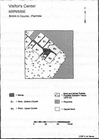 Figure 5. Plan view of hearth.
One cluster showed up on all three graphs. Located at 505 North/ 535 East, this cluster overlaid the brick hearth feature. This concentration represented a household activity area. A second distinct cluster was identified at 500 North/ 500 East. This area, which contained eighteenth-century ceramics, was not associated with any known features. This cluster may indicate the location of a household refuse midden. A third distinct concentration clustered at 520 North/ 520 East. This area contained wrought nails and was not associated with any known features. This may be the location of a non-domestic wooden structure.
The ceramic assemblage was composed of delftware, Rhenish German stoneware, white salt-glazed stoneware, Chinese export porcelain, creamware and pearlware. These ware types suggested a mid to late eighteenth-century occupation for the site. These wares were also indicative of household use. Utilitarian kitchen wares were not represented in this collection. Glass was also present, with 22 fragments of green bottle glass and 1 fragment of clear, leaded table glass.
The architectural material included 32 hand-wrought nails. The presence of brick and mortar was noted in the field. The small amount of brick and mortar encountered in the excavation units indicated that the structure was probably constructed of wood which rested on posts.
14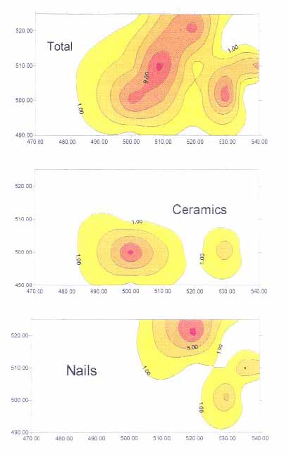 Figure 6. Surfer maps.
Chapter 4.
Summary and Management Recommendations
Research Summary
This Phase II project focused on the substantiation and delineation of an eighteenth-century domestic site which was previously identified during Phase I survey (Pickett 1996). This site is located adjacent to the Colonial Williamsburg Visitor's Center and the Colonial Parkway.
Testing of the area explored the concentrations of eighteenth-century material located during the initial survey. A total of twenty-four 75 cm by 75 cm units, two 1 m by 1 m units, and one 2 m by 2 m unit were excavated. These test units identified an eighteenth-century English-bond, brick hearth and an associated robber's trench. The sparse amount of brick encountered in the test units indicated that the structure was built of wood and rested on posts. Historical research indicated that the property may have been owned by Matthew Moody and sold in 1760 to Lieutenant Governor Francis Fauquier. Historically, little else is known about the nature of this structure. Archaeological evidence suggested a domestic site of an individual or family which was occupied during the second half of the eighteenth century.
A thin scatter of mid to late eighteenth-century domestic and architectural artifacts were also recovered. There was a high correlation between artifact density and the location of the brick hearth foundation. Artifact distribution maps also suggested the location of a household refuse midden and a non-domestic wooden structure.
Management Recommendations
Due to the historical significance of this site, a Phase III data recovery is recommended. Further excavation of the plowzone in the 40 m by 40 m area surrounding 505 North/ 535 East will allow a more thorough investigation into the function of the structure and the quality of life of its inhabitants. This house was probably occupied by either slaves of African origin or poor whites. A proposed strategy for excavation includes the hand excavation of 5% of the plowzone. Following this sampling a 40 m square area should be machine stripped with complete excavation for all exposed subsurface features.
References Cited
- 1930
- Speeches of Students of the College of William and Mary Delivered May 1, 1699. William and Mary Quarterly 10(2nd series):323-337.
- 1662-1702
- Pp.399-401, Act XIV (copy in Goodwin 1959) 1702
- 1986
- Toward A Resource Protection Process: James City County, York County, City of Poquoson, and the City Of Williamsburg. Department of Archaeological Research, Colonial Williamsburg Foundation, 1986.
- 1932
- Virginia Agricultural Decline to 1860: A Fallacy. Agricultural History 6:3-13.
- 1961
- We Were There: Descriptions of Williamsburg, 1699-1859. Manuscript on file, Department of Research, The Colonial Willliamsburg Foundation.
- 1949
- The Southern Colonies in the Seventeenth Century 1607-1689, Volume I, A History of the South. Lousiana State University Press and the Littlefield Fund for Southern History, University of Texas.
- 1781
- Carte des Environs de Williamsburg en Virginia on les Armes Francoise et Americaines ont Campes en Septembre 1781. Photostat on file. Special Collections, Colonial Williamsburg Foundation Library, Williamsburg, Virginia.
- 1996
- Personal Communication, Colonial Williamsburg Department of Archaeological Research, Williamsburg, Virginia.
- 1782
- Plan de la Ville et Environs de Williamsburg en Virginia, 1782. Photostat on file. Special Collections, Colonial Williamsburg Foundation Library, Williamsburg, Virginia.
- 1980
- "The Palace Lands 1700-1790" Manuscript on file at Colonial Williamsburg Foundation Library.
- 1995
- Phase II Archaeological Testing of the 320 North Henry Lot. Colonial Williamsburg Department of Archaeological Research, Williamsburg, VA. Prepared for the Colonial Williamsburg Foundation.
- 1996
- Phase I Archaeological Survey Of An Eighteen Acre Tract Adjacent To Colonial Williamsburg's Visitor Center. Unpublished Report. On file at the Department of Archaeological Research, Colonial Williamsburg Foundation. 17
- 1996
- Phase I Archaeological Survey of the Northington and Municipal Center Blocks. Colonial Williamsburg Department of Archaeological Research, Williamsburg, VA. Prepared for the City of Williamsburg.
- 1799
- Travel through the United States of North America … in the years 1795, 1796, and 1797. Vol. II, London.
- 1961
- "Block 36, Lot 212- 217 Historical Report." Originally reported in under the title "Colonial Lots 212- 217 Block 36." Colonial Williamsburg Foundation Library Research Report Series- 1620. Colonial Williamsburg Foundation Library, Williamsburg, Virginia.
- 1987
- Williamsburg quadrangle. 7.5-minute topographic series. USGS, Washington, D.C.
- 1991
- How to Apply the National Register Criteria for Evaluation. National Register Bulletin No. 15. U.S. Department of the Interior, National Park Service, Interagency Resources Division, Washington, D.C.
- 1985
- Soil Survey of James City and York Counties and the City of Williamsburg, Virginia. U.S. Soil Conservation Service in cooperation with Virginia Polytechnic Institute and State University, Blacksburg.
- 1928
- Map of Williamsburg, Virginia: Restoration Survey. Revised 1930. Photostat on file. Special Collections, Colonial Williamsburg Foundation Library, Williamsburg, Virginia.
Appendix A:
Artifact Inventory
Note: Inventory is printed from the Re:discovery cataloguing program used by Colonial Williamsburg, manufactured and sold by Re:discovery Software, Charlottesville, Virginia.
Brief explanation of terms:
Context No. Arbitrary designation for a particular deposit (layer or feature), consisting of a four-digit "site/area" designation and a five-digit context designation. The site/area for this project is "33AR."
TPQ "Date after which" the layer or feature was deposited, based on the artifact with the latest initial manufacture date. Deposits without a diagnostic artifact have the designation "NDA," or no date available.
Listing The individual artifact listing includes the catalog "line designation," followed by the number of fragments or pieces, followed by the description.
| AA | 4 | EARTHENWARE, DELFTWARE ENG, FRAGMENT, WHEEL THROWN |
| AB | 4 | EARTHENWARE, DELFTWARE ENG, FRAGMENT, PAINTED UNDER, WHEEL THROWN |
| AC | 1 | STONEWARE, WH SALT-GLAZED, FRAGMENT |
| AD | 1 | STONEWARE, WH SALT-GLAZED, FRAGMENT, PAINTED OVER, POLYCHROME |
| AE | 15 | IRON ALLOY, NAIL, 2 TO 4 IN, WIRE |
| AF | 1 | IRON ALLOY, NAIL, LESS THAN 2 IN, WIRE |
| AG | 4 | IRON ALLOY, NAIL, 2 TO 4 IN, WIRE, TWISTED SHANK |
| AH | 1 | IRON ALLOY, NAIL, WIRE, FRAGMENT |
| AA | 1 | EARTHENWARE, DELFTWARE ENG, FRAGMENT, WHEEL THROWN, YELLOW |
| AB | 2 | REFINED EARTHEN, CREAMWARE, FRAGMENT |
| AC | 1 | REFINED EARTHEN, CREAMWARE, FRAGMENT, FEATHER EDGE, PRESS MOLDED |
| AD | 1 | GLASS, CLRLESS LEAD, FRAGMENT, CONTAINER |
| AE | 2 | GLASS, FRAGMENT, WINE BOTTLE |
| AF | 1 | GLASS, FRAGMENT, WINDOW GLASS |
| AG | 3 | SHELL, SHELL |
| AH | 1 | BRICK, BRICKETAGE |
| AI | 1 | IRON ALLOY, NAIL, LESS THAN 2 IN, CUT |
| AJ | 1 | IRON ALLOY, UNID HARDWARE, FLAT IRON STRAP |
| AK | 2 | IRON ALLOY, UNID HARDWARE, MACHINE-MADE, ROLLED IRON, THREADED |
| AA | 2 | REFINED EARTHEN, CREAMWARE, FRAGMENT |
| AB | 1 | GLASS, FRAGMENT, WINDOW GLASS |
| AC | 1 | IRON ALLOY, OPENER, BOTTLE, MACHINE-MADE, BOTTLE OPENER |
| AA | 1 | STONEWARE, WESTERWALD, FRAGMENT, WHEEL THROWN |
| AB | 2 | BRICK, BRICKETAGE |
| AC | 1 | IRON ALLOY, NAIL, LESS THAN 2 IN, CUT |
| AD | 2 | IRON ALLOY, NAIL, 2 TO 4 IN, CUT |
| AE | 2 | IRON ALLOY, NAIL, CUT, FRAGMENT |
| AF | 3 | IRON ALLOY, UNID HARDWARE |
| AA | 1 | REFINED EARTHEN, CREAMWARE, FRAGMENT, FEATHER EDGE, PRESS MOLDED |
| AB | 1 | REFINED EARTHEN, CREAMWARE, FRAGMENT |
| AC | 2 | GLASS, FRAGMENT, WINE BOTTLE |
| AD | 1 | IRON ALLOY, NAIL, LESS THAN 2 IN, WROUGHT/FORGED |
| AE | 1 | IRON ALLOY, NAIL, LESS THAN 2 IN, CUT |
| AA | 2 | EARTHENWARE, DELFTWARE ENG, FRAGMENT, WHEEL THROWN |
| AB | 1 | REFINED EARTHEN, CREAMWARE, FRAGMENT |
| AC | 1 | REFINED EARTHEN, PEARLWARE, FRAGMENT |
| AD | 1 | STONEWARE, WH SALT-GLAZED, FRAGMENT, WHEEL THROWN |
| AE | 1 | BRICK, BRICKETAGE |
| AF | 3 | IRON ALLOY, NAIL, LESS THAN 2 IN, WROUGHT/FORGED |
| 20 | ||
| AG | 2 | IRON ALLOY, NAIL, 2 TO 4 IN, WROUGHT/FORGED |
| AH | 1 | IRON ALLOY, NAIL, WROUGHT/FORGED, FRAGMENT |
| AI | 4 | IRON ALLOY, UNID HARDWARE |
| AA | 1 | GALVAN METAL, FRAGMENT, MACHINE-MADE, 1/8 INCH WINDOW SCREEN |
| AB | 2 | IRON ALLOY, FRAGMENT, MACHINE-MADE, ELECTRICAL CONDUIT |
| AC | 6 | IRON ALLOY, WIRE, MACHINE-MADE, MULTIPLE PIECES TWISTED TOGETHER |
| AD | 1 | IRON ALLOY, SPIKE, WROUGHT/FORGED |
| AE | 3 | IRON ALLOY, NAIL, 2 TO 4 IN, WROUGHT/FORGED |
| AF | 4 | IRON ALLOY, NAIL, 2 TO 4 IN, CUT |
| AG | 11 | IRON ALLOY, NAIL, 2 TO 4 IN, WIRE |
| AH | 2 | IRON ALLOY, NAIL, LESS THAN 2 IN, WIRE |
| AI | 1 | IRON ALLOY, NAIL, WROUGHT/FORGED, FRAGMENT |
| AJ | 2 | IRON ALLOY, NAIL, WIRE, FRAGMENT |
| AA | 1 | EARTHENWARE, DELFTWARE ENG, FRAGMENT, WHEEL THROWN, MISSING GLAZE |
| AB | 1 | REFINED EARTHEN, CREAMWARE, FRAGMENT |
| AC | 1 | REFINED EARTHEN, PEARLWARE, FRAGMENT, PAINTED UNDER, BLUE |
| AD | 1 | CERAMIC, TOBACCO PIPE, IMPORTED, STEM, 4/64 INCHES |
| AE | 5 | GLASS, CLRLESS NON-LD, FRAGMENT, CONTAINER |
| AF | 2 | GLASS, CLRLESS NON-LD, FRAGMENT, CONTAINER, MOLD BLOWN |
| AG | 1 | GLASS, CLRLESS NON-LD, FRAGMENT, MOLD BLOWN, WHITE |
| AH | 1 | GLASS, FRAGMENT, WINDOW GLASS |
| AA | 3 | IRON ALLOY, NAIL, 2 TO 4 IN, WROUGHT/FORGED |
| AB | 6 | IRON ALLOY, NAIL, LESS THAN 2 IN, WROUGHT/FORGED |
| AC | 1 | IRON ALLOY, SPIKE, WROUGHT/FORGED |
| AD | 1 | IRON ALLOY, NAIL, 2 TO 4 IN, WIRE |
| AE | 5 | IRON ALLOY, DRAWER PULL |
| AF | 1 | COPPER ALLOY, CARTRIDGE CASE, MACHINE-MADE, BASE, SHOTGUN CASING |
| AG | 6 | IRON ALLOY, UNID HARDWARE, CAST |
| AA | 1 | CERAMIC, FRAGMENT, DRAINAGE PIPE |
| AA | 1 | STONEWARE, WESTERWALD, FRAGMENT, WHEEL THROWN |
| AB | 1 | PORCELAIN, CH PORCELAIN, FRAGMENT, PAINTED UNDER, BLUE |
| AC | 4 | GLASS, CLRLESS NON-LD, FRAGMENT, CONTAINER |
| AD | 1 | GLASS, CLRLESS NON-LD, FRAGMENT, CONTAINER, MOLD BLOWN, LETTERING/NUMB, ML |
| AE | 2 | GLASS, FRAGMENT, WINE BOTTLE |
| AF | 1 | OTHER SYNTHETIC, FRAGMENT, ASPHALT FRAGMENT |
| AA | 1 | WOOD, FRAGMENT |
| AB | 1 | IRON ALLOY, NAIL, 2 TO 4 IN, MANF. TECH. UNKNOWN |
| AC | 1 | GALVAN METAL, LOCK/LOCK PART, MACHINE-MADE, PAD LOCK, LOCK PLATE, HINGE AND SCREWS |
| AA | 1 | STONEWARE, WH SALT-GLAZED, FRAGMENT, DOT/DIAPER/BASK, PRESS MOLDED |
| AB | 1 | PORCELAIN, CH PORCELAIN, FRAGMENT, PAINTED UNDER, BLUE |
| AC | 8 | GLASS, FRAGMENT, WINE BOTTLE |
| AD | 1 | GLASS, FRAGMENT, WINDOW GLASS |
| AE | 1 | GALVAN METAL, NAIL, LESS THAN 2 IN, WIRE, ROOFING NAIL |
| AF | 2 | IRON ALLOY, NAIL, LESS THAN 2 IN, WROUGHT/FORGED |
| AA | 1 | GLASS, FRAGMENT, WINDOW GLASS |
| AA | 1 | COPPER ALLOY, UNID HARDWARE |
| AA | 2 | PORCELAIN, CH PORCELAIN, FRAGMENT, PAINTED UNDER, GHOST IMAGE |
| AB | 1 | GLASS, FRAGMENT, WINE BOTTLE |
| AC | 1 | BONE, FAUNAL SPECIMEN |
| AD | 2 | WOOD, CHARCOAL |
| AE | 2 | IRON ALLOY, NAIL, 2 TO 4 IN, WROUGHT/FORGED |
| AF | 1 | IRON ALLOY, NAIL, LESS THAN 2 IN, WROUGHT/FORGED |
| AA | 1 | GLASS, FRAGMENT, WINE BOTTLE |
| AB | 2 | IRON ALLOY, NAIL, 2 TO 4 IN, WROUGHT/FORGED |
| AC | 1 | IRON ALLOY, NAIL, 2 TO 4 IN, CUT |
| AD | 1 | IRON ALLOY, NAIL, CUT |
| AE | 1 | IRON ALLOY, NAIL, WIRE, FRAGMENT |
| AF | 3 | IRON ALLOY, NAIL, WROUGHT/FORGED, FRAGMENT |
| AG | 1 | IRON ALLOY, SPIKE, WIRE |
| AA | 1 | CERAMIC, FRAGMENT, DRAINAGE PIPE |
| AA | 3 | IRON ALLOY, NAIL, 2 TO 4 IN, WIRE |
| AB | 2 | IRON ALLOY, NAIL, LESS THAN 2 IN, WIRE |
| AC | 2 | IRON ALLOY, NAIL, ROOFING, WIRE |
| AD | 2 | IRON ALLOY, NAIL, FRAGMENT, MANF. TECH. UNKNOWN |
| AE | 1 | IRON ALLOY, FRAGMENT, MACHINE-MADE, ELECTRICAL CONDUIT |
| AF | 1 | IRON ALLOY, UNID HARDWARE, THIN, FLAT METAL |
| AA | 1 | PORCELAIN, CH PORCELAIN, FRAGMENT, PAINTED UNDER, BLUE |
| AB | 1 | IRON ALLOY, NAIL, 2 TO 4 IN, CUT |
| AC | 2 | IRON ALLOY, NAIL, LESS THAN 2 IN, CUT |
| AD | 2 | IRON ALLOY, NAIL, FRAGMENT, MANF. TECH. UNKNOWN |
| AE | 1 | IRON ALLOY, UNID HARDWARE, CAST |
| AA | 1 | IRON ALLOY, NAIL, 2 TO 4 IN, CUT |
| AA | 1 | IRON ALLOY, NAIL, 2 TO 4 IN, CUT |
| AB | 1 | IRON ALLOY, NAIL, FRAGMENT, MANF. TECH. UNKNOWN |
| AA | 1 | EARTHENWARE, DELFTWARE ENG, FRAGMENT, SURF DEGRADED |
| AB | 2 | IRON ALLOY, SPIKE, WIRE |
| AC | 4 | IRON ALLOY, NAIL, FRAGMENT, MANF. TECH. UNKNOWN |
| AD | 1 | COPPER ALLOY, CARTRIDGE CASE, MACHINE-MADE, BASE, SHOTGUN CASING |
| AA | 2 | EARTHENWARE, DELFTWARE ENG, FRAGMENT, PAINTED UNDER, BLUE |
| AB | 1 | REFINED EARTHEN, CREAMWARE, FRAGMENT, OTHER MOLD DEC, PRESS MOLDED |
| AC | 2 | REFINED EARTHEN, CREAMWARE, FRAGMENT, PRESS MOLDED |
| AD | 2 | REFINED EARTHEN, CREAMWARE, FRAGMENT |
| AE | 1 | STONEWARE, WH SALT-GLAZED, FRAGMENT, PRESS MOLDED |
| AF | 1 | PORCELAIN, CH PORCELAIN, FRAGMENT, PAINTED UNDER, BLUE |
| AG | 1 | CERAMIC, TOBACCO PIPE, IMPORTED, STEM, 4/64 INCHES |
| AH | 5 | GLASS, COLORED GLASS, FRAGMENT, CONTAINER, GREEN |
| AI | 4 | GLASS, FRAGMENT, WINE BOTTLE |
| AJ | 3 | GLASS, FRAGMENT, WINDOW GLASS, AQUA |
| AK | 1 | BRICK, BRICKETAGE |
| AL | 2 | SHELL, MORTAR, LIME |
| AM | 1 | SANDSTONE, STONE |
| AN | 1 | IRON ALLOY, NAIL, LESS THAN 2 IN, WROUGHT/FORGED |
| AO | 1 | IRON ALLOY, NAIL, CUT |
| AP | 8 | IRON ALLOY, NAIL, LESS THAN 2 IN, CUT |
| AQ | 10 | IRON ALLOY, NAIL, LESS THAN 2 IN, MANF. TECH. UNKNOWN |
| AR | 5 | IRON ALLOY, NAIL, FRAGMENT, MANF. TECH. UNKNOWN |
| AS | 1 | IRON ALLOY, WIRE, MACHINE-MADE |
| AT | 2 | IRON ALLOY, UNID HARDWARE, FLAT FRAGMENTS |
| AA | 1 | GLASS, COLORED GLASS, FRAGMENT, CONTAINER, AQUA |
| AB | 3 | GLASS, COLORED GLASS, FRAGMENT, CONTAINER, GREEN |
| AC | 1 | GLASS, FRAGMENT, WINE BOTTLE |
| AD | 1 | GLASS, FRAGMENT, WINDOW GLASS |
| AE | 2 | IRON ALLOY, NAIL, 2 TO 4 IN, CUT |
| AF | 3 | IRON ALLOY, NAIL, LESS THAN 2 IN, CUT |
| AG | 1 | IRON ALLOY, NAIL, LESS THAN 2 IN, CUT, ROSE-HEADED |
| AH | 3 | IRON ALLOY, NAIL, FRAGMENT, MANF. TECH. UNKNOWN |
| AA | 1 | REFINED EARTHEN, CREAMWARE, FRAGMENT |
| AB | 2 | IRON ALLOY, NAIL, 2 TO 4 IN, WROUGHT/FORGED |
| AC | 4 | IRON ALLOY, NAIL, LESS THAN 2 IN, CUT |
| AD | 7 | IRON ALLOY, NAIL, 2 TO 4 IN, WIRE |
| AE | 1 | IRON ALLOY, NAIL, 2 TO 4 IN, MANF. TECH. UNKNOWN |
| AF | 1 | IRON ALLOY, NAIL, LESS THAN 2 IN, MANF. TECH. UNKNOWN |
| AG | 6 | IRON ALLOY, NAIL, FRAGMENT |
| AH | 2 | TIN ALLOY, UNID HARDWARE, FLAT AND THIN |
| AI | 1 | IRON ALLOY, WIRE, MACHINE-MADE |
| AJ | 8 | IRON ALLOY, UNID HARDWARE, ONE FRAG. APPEARS TO BE CAST IRON |
| AA | 1 | GLASS, COLORED GLASS, FRAGMENT, CONTAINER, AMBER |
| AB | 1 | GLASS, FRAGMENT, WINE BOTTLE |
| AC | 1 | GLASS, FRAGMENT, WINDOW GLASS |
| AD | 1 | IRON ALLOY, SPIKE, WIRE |
| AE | 1 | IRON ALLOY, NAIL, 2 TO 4 IN, MANF. TECH. UNKNOWN |
| AF | 9 | IRON ALLOY, UNID HARDWARE, LARGE CHUNKS |